哈肯薩克河
外觀
此條目需要補充更多來源。 (2014年9月12日) |
| 哈肯薩克河 Hackensack River | |
|---|---|
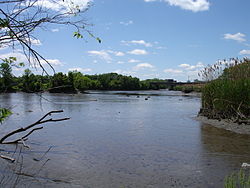
 哈肯薩克河一景,攝於退潮時分的提內克 | |
 帕塞伊克河與哈肯薩克河流域圖 | |
| 國家 | |
| 州 | |
| 縣 | 哈德遜縣、博根縣、羅克蘭縣 |
| 流域 | |
| 源頭 | |
| • 位置 | 美國紐約州羅克蘭縣West Haverstraw |
| • 座標 | 41°11′00″N 73°59′24″W / 41.18333°N 73.99000°W |
| • 海拔 | 120英尺(37米) |
| 河口 | 紐瓦克灣 |
| • 位置 | USANew JerseyHudson County |
| • 座標 | 40°42′55″N 74°06′42″W / 40.71528°N 74.11167°W |
| • 海拔 | 0英尺(0米) |
| 城市 | 哈肯薩克 |
| 本貌 | |
| 長度 | 54 mi(87 km) |
| 流量 | |
| • 地點 | West Nyack, NYNew Milford, NJ |
| • 平均流量 | 173 cu ft/s(4.9 m3/s) |
| • 最小流量 | 0 cu ft/s(0 m3/s) |
| • 最大流量 | 880 cu ft/s(25 m3/s) |
| 流量 | |
| • 地點 | West Nyack, NY |
| • 平均流量 | 58 cu ft/s(1.6 m3/s) |
哈肯薩克河(英語:Hackensack River)是流經美國紐約州和新澤西州的一條河流,長約72km,注入紐約港的紐瓦克灣。哈肯薩克河流域涵蓋了紐約下哈德遜河以西的郊區,與哈德遜河近似平行。19和20世紀遭工業污染,到21世紀初才隨著沿河製造業的衰退而有所好轉,但仍然受城市廢水排放的困擾。[1][2]
參考文獻
[編輯]- ^ Wright, Jim. "Hackensack River is getting cleaner." (頁面存檔備份,存於網際網路檔案館) The Record. August 26, 2007.
- ^ New Jersey Department of Environmental Protection. Trenton, NJ. "Watershed Management Area 5 Factsheet." (頁面存檔備份,存於網際網路檔案館) Bureau of Watershed Planning. July 17, 2007.
外部連結
[編輯]- Bergen SWAN(頁面存檔備份,存於網際網路檔案館) - Watershed Protection Group
- Hackensack Riverkeeper(頁面存檔備份,存於網際網路檔案館) - Environmental organization
- Hackensack River tides - Fairleigh Dickinson University
- Hackensack River bridges(頁面存檔備份,存於網際網路檔案館)
- Wild New Jersey: Fishes of the Hackensack River
- Friends of the Hackensack River Greenway through Teaneck(頁面存檔備份,存於網際網路檔案館)
- New Jersey Meadowlands Commission
- Meadowlands Environment Center
- Meadowlands Environmental Research Institute (MERI)(頁面存檔備份,存於網際網路檔案館)
- New Jersey Naval Museum Home of the W.W. II Submarine USS Ling (SS-297)
- USS Ling(頁面存檔備份,存於網際網路檔案館) Photos on board the Submarine USS Ling SS-297
- U.S. Geological Survey: NJ stream gaging stations(頁面存檔備份,存於網際網路檔案館)
