亞平寧山脈
外觀
此條目需要擴充。 (2018年11月2日) |
| 亞平寧山脈 Monti Appennini(義大利語) | |
|---|---|
 位處大薩索山國家公園內的科爾諾山 | |
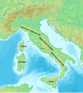
 Relief map of the Apennines | |
| 最高點 | |
| 山峰 | 科爾諾山 |
| 海拔 | 2,912公尺(9,554英尺) |
| 座標 | 42°28′9″N 13°33′57″E / 42.46917°N 13.56583°E |
| 規模 | |
| 長度 | 1,200公里(750英里) northwest to southeast |
| 寬度 | 250公里(160英里) southwest to northeast |
| 地理 | |
| 國家 | 義大利 and 聖馬利諾 |
| 山脈座標 | 43°16.9′N 12°34.9′E / 43.2817°N 12.5817°E |
| 地質 | |
| 岩石年代 | Mesozoic for formation of rock, Neogene-Quaternary for orogeny |
| 岩石類型 | Apennine fold and thrust belt |

亞平寧山脈(義大利語:Appennini[1]),位於亞平寧半島東側,是亞平寧半島的主幹山脈,北起阿爾卑斯山南麓,南至亞平寧半島南端,全長超過1000公里,最高峰科爾諾山。全境屬義大利管轄。
多懸崖峭壁的斷層式海岸。山脈係由一系列山地和丘陵組成的年輕褶皺帶,多火山和地震。
參考
[編輯]- ^ Entry Apennines, in Merriam-Webster Dictionary, on-line on www.merriam-webster.com (頁面存檔備份,存於網際網路檔案館).
外部連結
[編輯]- Ligurian Apennine. Summit Post. 2006 [16 February 2010].
- Italian Cultural Landscapes: wood-pasture and wood-meadow in the Ligurian-Tuscan-Aemilian Apennines, Italy. The ECL project. [16 February 2010]. (原始內容存檔於17 September 2007).
- Appenine(原文如此) deciduous montane forests. 陸地生態區. 世界野生動物基金會.
- Irlam, Michael J. The Great Apennine Tunnel. Mike's Railway History. 2009 [16 February 2010]. (原始內容存檔於2023-01-30).
- 10th Mountain Division – The Formative World War II Years. Dartmouth College Class of 1965. 2008 [16 February 2010]. (原始內容存檔於2011-07-17).
