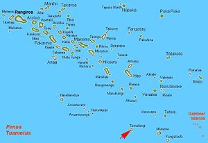
特馬坦吉環礁
外觀
21°40′S 140°37′W / 21.667°S 140.617°W

特馬坦吉環礁(Tematagi或Tematangi[1])是南太平洋法屬波利尼西亞的環礁,屬於土阿莫土群島的一部分,位於穆魯羅阿環礁東南161公里,長11.5公里、寬7公里,土地面積7.7平方公里,潟湖面積61平方公里,2002年總人口為53人。
參考資料
[編輯]- ^ Sailing Directions (enroute) for the Pacific Islands. Defense Mapping Agency, Hydrographic/Topographic Center. 2002: 13. (原始內容存檔於2021-11-27).
外部連結
[編輯]- Captain Bligh (頁面存檔備份,存於網際網路檔案館)
- History (頁面存檔備份,存於網際網路檔案館) & [1] (頁面存檔備份,存於網際網路檔案館)
- [2]
- Tematangi Atoll FP (EVS Islands) (頁面存檔備份,存於網際網路檔案館)
- Thoughts - Antipode of Qibla at Mecca (EVS Islands)
- Shuttle Image ISS004-E-6727 (Astronaut Photography) (頁面存檔備份,存於網際網路檔案館)
- Shuttle Image ISS009-E-6082 (Astronaut Photography)
- Tematangi Atoll FP (Oceandots.com)
- Tuamotu Atolls List (Pacific Image)
| 這是一篇與法屬波利尼西亞地理相關的小作品。您可以透過編輯或修訂擴充其內容。 |
