奧雷亞穆諾縣
外观
| 奧雷亞穆諾縣 | |
|---|---|
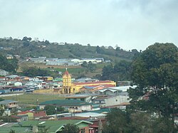
 在奧雷亞穆諾縣的Cot town。 | |
 奧雷亞穆諾縣 | |
| 坐标:9°59′50″N 83°52′37″W / 9.9972861°N 83.8769838°W | |
| 国家 | |
| 建立日期 | 1914年8月17[1] |
| 面积 | |
| • 总计 | 202.31 平方公里(78.11 平方英里) |
| 海拔 | 1,861 公尺(6,106 英尺) |
| 人口(2011) | |
| • 總計 | 45,473人 |
| • 密度 | 225人/平方公里(582人/平方英里) |
| 时区 | UTC−06:00 |
| 網站 | www |
奧雷亞穆諾縣(西班牙語:Cantón de Oreamuno),是哥斯達黎加的縣份,位於該國西北部,由卡塔戈省負責管轄,首府設於聖拉斐爾德奧雷亞穆諾,始建於1914年8月17日[2],面積202.31平方公里,2011年人口45,473人,人口密度每平方公里224.77人。
外部链接
[编辑]参考资料
[编辑]- ^ Hernández, Hermógenes. Costa Rica: evolución territorial y principales censos de población 1502 - 1984 1. San José: Editorial Universidad Estatal a Distancia. 1985: 164–173 [5 October 2020]. ISBN 9977-64-243-5. (原始内容存档于2020-10-08) (西班牙语).
- ^ Hernández, Hermógenes. Costa Rica: evolución territorial y principales censos de población 1502 - 1984 1. San José: Editorial Universidad Estatal a Distancia. 1985: 164–173 [5 October 2020]. ISBN 9977-64-243-5. (原始内容存档于2020-10-08) (西班牙语).

