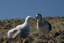
圖比耶爾高原
外观


37°51′S 77°33′E / 37.850°S 77.550°E
圖比耶爾高原(法語:Plateau des Tourbières),是南極洲上阿姆斯特丹岛的半島,由法屬南部領地負責管轄,最高點海拔高度881米,其中8平方公里地區被國際鳥盟列為重點鳥區。
參考資料
[编辑]- Diomedea amsterdamensis. IUCN Red List of Threatened Species. Version 2010. IUCN. 2010 [2011-05-01]. (原始内容存档于2011-05-13).
- Berteaux, D.; & Micol, T. Population studies and reproduction of the feral cattle (Bos taurus) of Amsterdam Island, Indian Ocean (PDF). Journal of Zoology. 1992, 228 (2): 265–276 [2014-06-13]. doi:10.1111/j.1469-7998.1992.tb04607.x. (原始内容 (PDF)存档于2011-08-13).
| 这是一篇與南极洲地理相關小作品。您可以通过编辑或修订扩充其内容。 |
