
File:Map of language areas of Xinjiang.png
預覽大小:800 × 448 像素。 其他解析度:320 × 179 像素 | 640 × 358 像素 | 1,188 × 665 像素。
原始檔案 (1,188 × 665 像素,檔案大小:844 KB,MIME 類型:image/png)
檔案歷史
點選日期/時間以檢視該時間的檔案版本。
| 日期/時間 | 縮圖 | 尺寸 | 使用者 | 備註 | |
|---|---|---|---|---|---|
| 目前 | 2011年11月23日 (三) 23:36 | | 1,188 × 665(844 KB) | Quigley | Better grammar and correct names in legend |
| 2006年10月23日 (一) 00:04 |  | 1,188 × 665(839 KB) | Postmann Michael~commonswiki | new vision | |
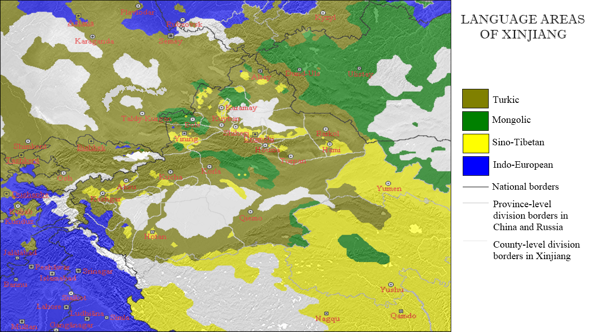
| 2006年10月22日 (日) 21:49 |  | 966 × 576(69 KB) | Postmann Michael~commonswiki | This map shows the language areas of the largest peoples in the Chinese part of the old Turkistan (so-called "East-Turkistan" and/or "Chinese Turkistan") with the adjacent states. This map is based on the map of http://www.hunmagyar.org/tf-tn/uygur/eturk |
檔案用途
下列頁面有用到此檔案:
全域檔案使用狀況
以下其他 wiki 使用了這個檔案:
- af.wikipedia.org 的使用狀況
- azb.wikipedia.org 的使用狀況
- ca.wikipedia.org 的使用狀況
- cs.wikipedia.org 的使用狀況
- en.wikipedia.org 的使用狀況
- es.wikipedia.org 的使用狀況
- fa.wikipedia.org 的使用狀況
- fi.wikipedia.org 的使用狀況
- fr.wikipedia.org 的使用狀況
- incubator.wikimedia.org 的使用狀況
- lez.wikipedia.org 的使用狀況
- lv.wikipedia.org 的使用狀況
- mk.wikipedia.org 的使用狀況
- mn.wikipedia.org 的使用狀況
- ms.wikipedia.org 的使用狀況
- pnb.wikipedia.org 的使用狀況
- pt.wikipedia.org 的使用狀況
- ru.wikipedia.org 的使用狀況
- sk.wikipedia.org 的使用狀況
- tr.wikipedia.org 的使用狀況
- ug.wikipedia.org 的使用狀況
- uk.wikipedia.org 的使用狀況
- uz.wikipedia.org 的使用狀況
- wuu.wikipedia.org 的使用狀況