美國最長河流列表
外觀

在水文學中,幹流是指「河川下游內、對比於支流的主要河段」[註 1]。美國地質調查局(USGS)透過列出兩個端點(即河源和河口)的坐標來定義幹流。在美國境內,有38條河流的幹流長達500英里(800公里)或以上。而部份著名的河流如阿查法拉亞河[2]、威拉米特河[3]及薩斯奎哈納河[4],則因其幹流短於500英里(800公里)而未被納入列表內。
表列河流中有七條流越兩國或形成國界。育空河及哥倫比亞河發源於加拿大,隨後流入美國。牛奶河、聖勞倫斯河及雷德河則始於美國,然後流入加拿大。而在上述河流中,只有牛奶河兩度跨越國界——伏出、並再度流入美國[5]。科羅拉多河和格蘭德河等兩條河發源自美國,隨後流入墨西哥[5]。此外,密西西比河和密蘇里河的流域延伸入加拿大境內[6][7],希拉河的流域則延伸入墨西哥境內[8]。
在報告水文量時,不同的資料來源的精確度可能存在著差異。湖泊學家及作者露絲·帕特里克(Ruth Patrick)在描述一張美國高流量河流的圖表時表示,她向不同作者諮詢有關流量、排水面積和河流長度等數據,但結果他們所給出的數據有著很大的差異[9]。因此,帕特里克在書中指「似乎最明智的做法是將現有的數據表視為顯示河流的一般排名,且不要過分重視數據的微小差異(10%至20%)」[註 2][9]。
列表
[編輯]在下表內,流域面積及流量等數據的主要來源為《Rivers of North America》一書,如果不同資料來源所給出的數據差異大於10%,則會以註釋說明。在展示河流長度、流域面積及河流流量數據時,其量度單位會以英制及公制一併表示。而河流流量是指河水流經河口時的流量[註 3]。在「流經國家/州分及圖像」一欄,若出現非美國的州分,則會在旁標示。
另外,此列表中會以:
- 黃色背景代表該河流並不完全位於美國境內
- 綠色背景代表河流流域並不完全位於美國境內
地圖
[編輯]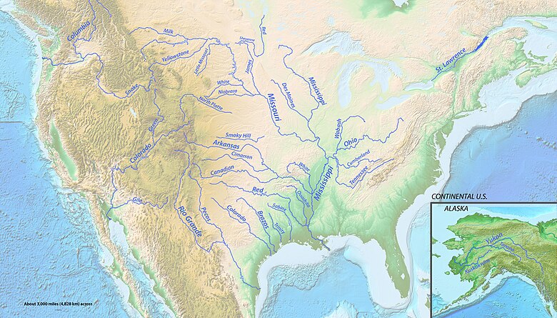
相關條目
[編輯]註釋及參考資料
[編輯]- 註釋
- ^ 原文為「the primary downstream segment of a river, as contrasted to its tributaries.」[1]。
- ^ 原文為「It seems...that the wisest course is to regard data tables such as the present one as showing the general ranks of rivers, and not to place too much importance on minor (10–20%) differences in figures.」[9]。
- ^ 隨著時間的流逝,因應農業發展而進行河流改道、水壩的興建以及其他人類對河流所施行的改造工程,均導致部分河流的流量出現很大的變化[10]。例如,科羅拉多河的原始流量根據估計為20,000立方英尺每秒(566立方米每秒),而2005年時其流量則為1,400立方英尺每秒(40立方公尺每秒)[10]。
- ^ 密蘇里河流域面積中有10,700平方英里(28,000平方公里)位在加拿大境內,約佔流域總面積的2%[6][7]。
- ^ 卡默勒(Kammerer):76,200立方英尺每秒(2,160立方公尺每秒)[16]。
- ^ 卡默勒(Kammerer):2,340英里(3,770公里)[16]。《加拿大地圖集》(Atlas of Canada):2,348英里(3,779公里)[6]。
- ^ 密西西比河流域面積中有10,700平方英里(27,800平方公里)位於加拿大境內,約佔流域總面積的2%[6][7]。
- ^ 育空河有714英里(1,149公里)的河道位在加拿大境內,約佔幹流長度的36%[6]。
- ^ 《加拿大地圖集》(Atlas of Canada)還列出了流域總面積為324,000平方英里(839,200平方公里),其中125,000平方英里(323,800平方公里)位於加拿大境內,而其餘199,000平方英里(515,400平方公里)則位於美國境內,兩者分別約佔整體39%及61%[6]。
- ^ 卡默勒(Kammerer):1,900英里(3,100公里)[16]。德克薩斯大學:1,799英里(2,895公里)[24]。格蘭德河形成了美、墨兩國的邊界,從德克薩斯州的艾爾帕索延伸至墨西哥灣,長度為1,251英里(2,013公里),約為其幹流長度的70%[24]。
- ^ 《Rivers of North America》一書指出,在整個格蘭德河流域面積中,只有170,000平方英里(450,000平方公里)對河流水量有所貢獻[26]。根據德克薩斯大學的研究,格蘭德河盆地中有約215,338平方英里(557,722平方公里)的面積能夠匯集雨水、融雪和泉水,其中並包括封閉流域[24]。在不計入封閉流域的情況下,流域面積中的87,020平方英里(225,380平方公里)位於墨西哥境內,93,821平方英里(242,994平方公里)則位於美國境內,兩者分別約佔整體面積的48%及52%[24]。另外,J.C.卡默勒(J.C. Kammerer)指出整個格蘭德河流域面積為336,000平方英里(870,000平方公里)[16]。
- ^ 根據猶他州水利部門的說法,科羅拉多河有75英里(121公里)長的河道位於墨西哥境內,約佔幹流長度的5%[27]。而在其中,大約17英里(27公里)長的河道位於美墨邊界[28]。
- ^ 根據聯合國環境署發表的報告,科羅拉多河的流域總面積為246,000平方英里(637,000平方公里),其中2,000平方英里(5,200平方公里)位於墨西哥,244,000平方英里(632,000平方公里)位於美國,兩者分別約佔整體1%及99%[28]。
- ^ 以卡默勒(Kammerer)所得出的數據(1,459英里(2,348公里))[16]再減去東福克阿肯色河的大約長度(16英里(26公里))[31]而得出。
- ^ 哥倫比亞河有大約498英里(801公里)長的河道位於加拿大境內,約佔幹流長度的40%[6]。
- ^ 《加拿大地圖集》(Atlas of Canada)列出的流域總面積為259,200平方英里(671,300平方公里),其中39,700平方英里(102,800平方公里)位於加拿大,而其餘219,500平方英里(568,500平方公里)則位於加美國境內,兩者分別約佔整體15%及85%[6]。另外,卡默勒(Kammerer)的數據則表示流域總面積為265,000平方英里(690,000平方公里)[16]。
- ^ 此長度是以幹流的長度1,360英里(2,190公里)[37],減去土撥鼠鎮福克紅河的長度160英里(260公里)[38]及鐵拉布蘭卡溪的長度75英里(121公里)[39]。另外,卡默勒(Kammerer)的數據則是1,290英里(2,080公里)[16]。
- ^ 卡默勒(Kammerer):93,200平方英里[16]。
- ^ 卡默勒(Kammerer):56,000立方英尺每秒(1,600立方公尺每秒)[16]。
- ^ 這項數據是透過把1982年至1994年的平均排放量相加,然後除以13而得出的。
- ^ 根據《加拿大百科全書》(The Canadian Encyclopedia),牛奶河有一條約110英里(170公里)長的支流伏經加拿大,該長度約為幹流長度的18%[84]。
- ^ 《加拿大地圖集》(Atlas of Canada):在牛奶河的流域總面積23,600平方英里(61,200平方公里)中,加拿大佔了8,300平方英里(21,600平方公里),而美國則佔了15,300平方英里(39,600平方公里),兩者分別約佔整體35%及65%[6]。
- ^ 根據美國陸軍工兵部隊的資料,聖勞倫斯河的其中一段長115英里(185公里)的河段構成了一部分的美加邊界,約佔幹流長度的19%[91]。
- ^ 卡默勒(Kammerer):396,000平方英里(1,030,000平方公里)[16]。《加拿大地圖集》(Atlas of Canada):519,000平方英里(1,344,200平方公里),加拿大佔了324,000平方英里(839,200平方公里),而美國則佔了195,000平方英里(505,000平方公里),兩者分別約佔整體62%及38%[6]。
- ^ 卡默勒(Kammerer):348,000立方英尺每秒(9,900立方公尺每秒)[16]。
- ^ 在希拉河的流域總面積中,只有232平方英里(600平方公里)位於墨西哥的索諾拉州,約佔整體0.4%,而其餘則位於美國境內[8]。
- ^ 《Rivers of North America》一書則指希拉河的河流流量少於210立方英尺每秒(6立方米每秒)。
- ^ 此數據是金德里德附近的水位監測站的上游流域面積,而河流英里為67.9(換算為河流公里則是109.3)[100]。
- ^ 此數據是由金德里德附近的水位監測站所測量的平均流量,而該處的河流英里為67.9(換算為河流公里則是109.3)[100]。
- ^ 幹流長度是以卡默勒(Kammerer)的數據(659英里(1,061公里))減去納貝斯納河的長度而得出的[16]。納貝斯納河大約長75英里(121公里),這是透過將納貝斯納河口到坎普河(Camp Creek)的距離60英里(97公里)[101],再加上從坎普河到納貝斯納冰川的距離15英里(24公里)[102]而得出的。
- ^ 數據僅反映出恩特普賴斯附近的水位監測站、其上方的一部分盆地面積,而該處的河流英里為43.3(換算為河流公里則是69.7)[106]。
- ^ 數據由位於恩特普賴斯附近的水位監測站所測量,而該處的河流英里為43.3(換算為河流公里則是69.7)[106]。
- ^ 此數據只是整個盆地的近似值,並不包括河流水位計以下的一小部分盆地(其位於河口上游約25英里(40公里)處)[111]。
- ^ 這項數據是透過把1990年至2010年的平均排放量相加,然後除以21而得出的。
- ^ 根據明尼蘇達州自然資源部的資料,雷德河有大約394英里(634公里)長的河道位於美國境內,約佔幹流長度的72%[116]。
- ^ 在雷德河的流域面積中,其中53,500平方英里(138,600平方公里)位於加拿大境內,而其餘57,500平方英里(148,900平方公里)則位於美國境內,兩者分別約佔整體48%及52%[16]。
- 參考資料
- ^ Benke & Cushing 2005,第1137頁.
- ^ Benke & Cushing 2005,第236頁.
- ^ Benke & Cushing 2005,第615頁.
- ^ Benke & Cushing 2005,第50頁.
- ^ 5.0 5.1 5.2 5.3 Rand McNally and Company. The road atlas 2008 : United States, Canada, and Mexico.. Chicago, IL: Rand McNally. 2008. ISBN 0-528-93961-0 (英語).
- ^ 6.00 6.01 6.02 6.03 6.04 6.05 6.06 6.07 6.08 6.09 6.10 6.11 6.12 The Atlas of Canada. Rivers. Natural Resources Canada. [2020-07-19]. (原始內容存檔於2007-04-04) (英語).
- ^ 7.0 7.1 7.2 Missouri River Basin basic geography and natural features. United States Geological Survey. [2020-07-19]. (原始內容存檔於2014-04-07) (英語).
- ^ 8.0 8.1 McCord, Marc W. Gila River. Wind Spirit Community. [2020-07-19]. (原始內容存檔於2018-08-14) (英語).
- ^ 9.0 9.1 9.2 Patrick 1995,第24頁.
- ^ 10.0 10.1 10.2 Benke & Cushing 2005,第527頁.
- ^ 11.0 11.1 11.2 所有河口和河源的座標皆取自地名資訊系統(GNIS,美國地質調查局)或加拿大地名數據庫,除了科羅拉多河的河口由Google地球地理定位。
- ^ 12.0 12.1 數據取自《Rivers of North America》一書,除非另外作註。
- ^ Benke & Cushing 2005,第432頁.
- ^ Geographic Names Information System (GNIS). Missouri River. United States Geological Survey. 1980-10-24 [2020-07-19]. (原始內容存檔於2022-10-11) (英語).
- ^ Benke & Cushing 2005,第469頁.
- ^ 16.00 16.01 16.02 16.03 16.04 16.05 16.06 16.07 16.08 16.09 16.10 16.11 16.12 16.13 16.14 16.15 Kammerer, J.C. Largest Rivers in the United States. United States Geological Survey. 2005-09-01 [2020-07-20]. (原始內容存檔於2002-11-15) (英語).
- ^ Benke & Cushing 2005,第237, 331頁.
- ^ Geographic Names Information System (GNIS). Mississippi River. United States Geological Survey. 1980-06-04 [2020-07-19]. (原始內容存檔於2022-05-29) (英語).
- ^ Benke & Cushing 2005,第272頁.
- ^ Atlin Lake (B.C.). Natural Resources Canada. [2020-07-19]. (原始內容存檔於2011-07-06) (英語).
- ^ Geographic Names Information System (GNIS). Yukon River. United States Geological Survey. 1981-03-31 [2020-07-19]. (原始內容存檔於2022-08-16) (英語).
- ^ Benke & Cushing 2005,第796頁.
- ^ Benke & Cushing 2005,第186頁.
- ^ 24.0 24.1 24.2 24.3 Patino, Carlos; McKinney, Daene C.; Maidment, David R. Water Management Information System for the Rio Grande/Bravo Basi. University of Texas Center for Research in Water Resources. [2020-07-20]. (原始內容存檔於2015-04-01) (英語).
- ^ Geographic Names Information System (GNIS). Rio Grande. United States Geological Survey. 1979-03-30 [2020-07-20]. (原始內容存檔於2022-01-24) (英語).
- ^ 26.0 26.1 Benke & Cushing 2005,第220頁.
- ^ Anderson, D. Larry. Utah's Perspective: The Colorado River (PDF). Utah Department of Natural Resources. 2002-05 [2020-07-20]. (原始內容 (PDF)存檔於2014-04-09) (英語).
- ^ 28.0 28.1 Arias, E.; Albar, M.; Parra, I.; Reza, M. Regional Definition (PDF). United Nations Environment Programme. [2020-07-20]. (原始內容 (PDF)存檔於2017-05-31) (英語).
- ^ Geographic Names Information System (GNIS). Colorado River. United States Geological Survey. 1980-02-08 [2020-07-20]. (原始內容存檔於2022-04-09) (英語).
- ^ 由Google地球地理定位。
- ^ Colorado Atlas and Gazetteer (地圖). DeLorme. § 47–48. 1998. ISBN 978-0-89933-265-9.
- ^ Geographic Names Information System (GNIS). Arkansas River. United States Geological Survey. 1979-11-30 [2020-07-20]. (原始內容存檔於2022-08-12) (英語).
- ^ Benke & Cushing 2005,第315頁.
- ^ Columbia Lake. Natural Resources Canada. [2020-07-20]. (原始內容存檔於2011-07-06) (英語).
- ^ Geographic Names Information System (GNIS). Columbia River. United States Geological Survey. 1980-11-28 [2020-07-20]. (原始內容存檔於2022-03-07) (英語).
- ^ Benke & Cushing 2005,第646頁.
- ^ Kleiner, Diana J. Handbook of Texas: Red River. Texas State Historical Association. [2020-07-20]. (原始內容存檔於2015-12-23) (英語).
- ^ Handbook of Texas: Prairie Dog Town Fork of the Red River. Texas State Historical Association. [2020-07-20]. (原始內容存檔於2016-03-14) (英語).
- ^ Handbook of Texas: Tierra Blanca Creek. Texas State Historical Association. [2020-07-20]. (原始內容存檔於2018-07-10) (英語).
- ^ Geographic Names Information System (GNIS). Red River. United States Geological Survey. 1980-06-04 [2020-07-20]. (原始內容存檔於2022-10-25) (英語).
- ^ Benke & Cushing 2005,第317頁.
- ^ Geographic Names Information System (GNIS). Snake River. United States Geological Survey. 1979-09-10 [2020-07-20]. (原始內容存檔於2022-07-02) (英語).
- ^ Benke & Cushing 2005,第643頁.
- ^ Benke & Cushing 2005,第379頁.
- ^ Geographic Names Information System (GNIS). Ohio River. United States Geological Survey. 1980-10-24 [2020-07-21]. (原始內容存檔於2022-01-24) (英語).
- ^ Benke & Cushing 2005,第413頁.
- ^ Benke & Cushing 2005,第198頁.
- ^ Geographic Names Information System (GNIS). Colorado River of Texas. United States Geological Survey. 1979-11-30 [2020-07-21]. (原始內容存檔於2021-10-30) (英語).
- ^ Benke & Cushing 2005,第222頁.
- ^ Benke & Cushing 2005,第384頁.
- ^ Geographic Names Information System (GNIS). Tennessee River. United States Geological Survey. 1979-09-20 [2020-07-21]. (原始內容存檔於2022-01-19) (英語).
- ^ Benke & Cushing 2005,第414頁.
- ^ Geographic Names Information System (GNIS). Canadian River. United States Geological Survey. 1979-12-18 [2020-07-21]. (原始內容存檔於2022-04-11) (英語).
- ^ Benke & Cushing 2005,第316頁.
- ^ Benke & Cushing 2005,第203頁.
- ^ Geographic Names Information System (GNIS). Brazos River. United States Geological Survey. 1979-11-30 [2020-07-21]. (原始內容存檔於2022-04-10) (英語).
- ^ Benke & Cushing 2005,第223頁.
- ^ Benke & Cushing 2005,第497頁.
- ^ Geographic Names Information System (GNIS). Green River. United States Geological Survey. 1979-12-31 [2020-07-21]. (原始內容存檔於2022-04-22) (英語).
- ^ Benke & Cushing 2005,第528頁.
- ^ Benke & Cushing 2005,第213頁.
- ^ Geographic Names Information System (GNIS). Pecos River. United States Geological Survey. 1979-11-30 [2020-07-21]. (原始內容存檔於2022-04-07) (英語).
- ^ Benke & Cushing 2005,第225頁.
- ^ Benke & Cushing 2005,第246頁.
- ^ Geographic Names Information System (GNIS). White River. United States Geological Survey. 1980-04-30 [2020-07-21]. (原始內容存檔於2021-10-30) (英語).
- ^ Benke & Cushing 2005,第273頁.
- ^ River Facts. American Rivers. [2020-07-21]. (原始內容存檔於2012-03-10) (英語).
- ^ Geographic Names Information System (GNIS). James River. United States Geological Survey. 1980-02-13 [2020-07-21]. (原始內容存檔於2021-10-30) (英語).
- ^ 69.0 69.1 USGS 06478513 James River near Yankton, SD. United States Geological Survey. 2010-11 [2020-07-21]. (原始內容存檔於2015-09-08) (英語).
- ^ Benke & Cushing 2005,第741頁.
- ^ Geographic Names Information System (GNIS). Kuskokwim River. United States Geological Survey. 2000-01-01 [2020-07-21]. (原始內容存檔於2022-04-07) (英語).
- ^ Benke & Cushing 2005,第764頁.
- ^ O'Dell, Larry. Cimarron River. Oklahoma Historical Society. [2020-07-21]. (原始內容存檔於2014-12-27) (英語).
- ^ Geographic Names Information System (GNIS). Cimarron River. United States Geological Survey. 1979-12-18 [2020-07-21]. (原始內容存檔於2021-10-30) (英語).
- ^ Benke & Cushing 2005,第319頁.
- ^ Benke & Cushing 2005,第390頁.
- ^ Geographic Names Information System (GNIS). Cumberland River. United States Geological Survey. 1979-09-20 [2020-07-21]. (原始內容存檔於2021-10-30) (英語).
- ^ Benke & Cushing 2005,第415頁.
- ^ Benke & Cushing 2005,第440頁.
- ^ Geographic Names Information System (GNIS). Yellowstone River. United States Geological Survey. 1980-02-13 [2020-07-21]. (原始內容存檔於2022-01-21) (英語).
- ^ Benke & Cushing 2005,第470頁.
- ^ 82.0 82.1 Benke & Cushing 2005,第451頁.
- ^ Geographic Names Information System (GNIS). North Platte River. United States Geological Survey. 1978-10-13 [2020-07-21]. (原始內容存檔於2022-06-24) (英語).
- ^ Marsh, James H. Milk River. Historica Canada. 2015-03-04 [2020-07-21]. (原始內容存檔於2020-04-29) (英語).
- ^ Geographic Names Information System (GNIS). Milk River. United States Geological Survey. 1980-04-04 [2020-07-21]. (原始內容存檔於2021-10-30) (英語).
- ^ Benke & Cushing 2005,第475頁.
- ^ Benke & Cushing 2005,第265頁.
- ^ Geographic Names Information System (GNIS). Ouachita River. United States Geological Survey. 2000-01-01 [2020-07-21]. (原始內容存檔於2022-05-08) (英語).
- ^ Benke & Cushing 2005,第279頁.
- ^ Benke & Cushing 2005,第987頁.
- ^ St. Lawrence River (International Section). U.S. Army Corps of Engineers, Detroit District. [2020-07-21]. (原始內容存檔於2018-08-15) (英語).
- ^ Geographic Names Information System (GNIS). St. Lawrence River St. Lawrence River. United States Geological Survey. 2000-01-01 [2020-07-21]. (原始內容存檔於2022-01-19) (英語).
- ^ Saint Lawrence River. Natural Resources Canada. [2020-07-21]. (原始內容存檔於2011-07-06) (英語).
- ^ Benke & Cushing 2005,第983頁.
- ^ Benke & Cushing 2005,第511頁.
- ^ Geographic Names Information System (GNIS). Gila River. United States Geological Survey. 1980-02-08 [2020-07-21]. (原始內容存檔於2022-05-25) (英語).
- ^ Benke & Cushing 2005,第531頁.
- ^ 98.0 98.1 98.2 98.3 National Hydrography Dataset. United States Geological Survey. 2011-07-26 [2020-07-21]. (原始內容存檔於2011-12-13) (英語).
- ^ Geographic Names Information System (GNIS). Sheyenne River. United States Geological Survey. 1980-02-13 [2020-07-21]. (原始內容存檔於2021-11-11) (英語).
- ^ 100.0 100.1 Water-Data Report 2010: 05059000 Sheyenne River near Kindred, ND (PDF). United States Geological Survey. 2010 [2020-07-21]. (原始內容存檔 (PDF)於2011-10-28) (英語).
- ^ Irwin, Thomas. Recordable Disclaimer of Interest Application for the Nabesna River (PDF). U.S. Bureau of Land Management. 2005-10-03 [2020-07-21]. (原始內容 (PDF)存檔於2012-10-19) (英語).
- ^ Alaska Atlas and Gazetteer (地圖) 7th. DeLorme: 98. 2010. ISBN 0-89933-289-7.
- ^ Geographic Names Information System (GNIS). Tanana River. United States Geological Survey. 2000-01-01 [2020-07-21]. (原始內容存檔於2021-10-30) (英語).
- ^ Benke & Cushing 2005,第797頁.
- ^ Geographic Names Information System (GNIS). Smoky Hill River. United States Geological Survey. 1978-10-13 [2020-07-21]. (原始內容存檔於2021-10-30) (英語).
- ^ 106.0 106.1 Water-Data Report 2010: 06877600 Smoky Hill River at Enterprise, KS United States Geological Survey (PDF). [2020-07-21]. (原始內容存檔 (PDF)於2018-09-01) (英語).
- ^ Geographic Names Information System (GNIS). Niobrara River. United States Geological Survey. 1979-03-03 [2020-07-21]. (原始內容存檔於2021-10-30) (英語).
- ^ Benke & Cushing 2005,第478頁.
- ^ Personius, Robert Giles; Eddy, Samuel. Fishes of the Little Missouri River. Copeia (American Society of Ichthyologists and Herpetologists). 1955-02-18, 1955 (1): 41. doi:10.2307/1439450.
- ^ Geographic Names Information System (GNIS). Little Missouri River. United States Geological Survey. 1980-02-13 [2020-07-21]. (原始內容存檔於2022-07-25) (英語).
- ^ 111.0 111.1 111.2 USGS 06337000 Little Missouri River near Watford City, ND. United States Geological Survey. [2020-07-21]. (原始內容存檔於2020-07-21) (英語).
- ^ Benke & Cushing 2005,第208頁.
- ^ Geographic Names Information System (GNIS). Sabine River. United States Geological Survey. 1980-06-04 [2020-07-21]. (原始內容存檔於2021-10-30) (英語).
- ^ Benke & Cushing 2005,第224頁.
- ^ Red River of the North State Water Trail. Minnesota Department of Natural Resources. [2020-07-21]. (原始內容存檔於2020-07-21) (英語).
- ^ Red River of the North: A Water Trail Guide (PDF). Minnesota Department of Natural Resources. 2010 [2020-07-21]. (原始內容存檔 (PDF)於2019-08-05) (英語).
- ^ Geographic Names Information System (GNIS). Red River of the North. United States Geological Survey. 2000-01-01 [2020-07-21]. (原始內容存檔於2021-10-30) (英語).
- ^ Red River. Natural Resources Canada. [2020-07-21]. (原始內容存檔於2011-07-06) (英語).
- ^ Benke & Cushing 2005,第896頁.
- ^ National Recreation Trails: Des Moines River Water Trail (North Section), Polk County, Iowa. American Trails. 2018-03-26 [2020-07-21]. (原始內容存檔於2019-10-14) (英語).
- ^ National Recreation Trails: Des Moines River Water Trail (South Section), Polk County, Iowa. American Trails. 2018-03-26 [2020-07-21]. (原始內容存檔於2019-10-14) (英語).
- ^ Geographic Names Information System (GNIS). Des Moines River. United States Geological Survey. 1979-04-30 [2020-07-21]. (原始內容存檔於2021-10-30) (英語).
- ^ Benke & Cushing 2005,第372頁.
- ^ Benke & Cushing 2005,第445頁.
- ^ Geographic Names Information System (GNIS). White River. United States Geological Survey. 1980-02-13 [2020-07-21]. (原始內容存檔於2021-10-30) (英語).
- ^ Benke & Cushing 2005,第471頁.
- ^ Benke & Cushing 2005,第215頁.
- ^ Geographic Names Information System (GNIS). Trinity River. United States Geological Survey. 1979-11-30 [2020-07-21]. (原始內容存檔於2021-10-30) (英語).
- ^ Benke & Cushing 2005,第227頁.
- ^ Geographic Names Information System (GNIS). Wabash River. United States Geological Survey. 1979-11-30 [2020-07-21]. (原始內容存檔於2022-07-02) (英語).
- ^ Benke & Cushing 2005,第396頁.
參考文獻
[編輯]- Benke, Arthur C.; Cushing, Colbert E. Rivers of North America. Burlington, MA: Elsevier Academic Press. 2005. ISBN 978-0-12-088253-3 (英語).
- Patrick, Ruth. Rivers of the United States: Volume II: Chemical and Physical Characteristics. New York, NY: John Wiley & Sons. 1995. ISBN 978-0-471-10752-1 (英語).


