跳转到内容

File:Las Vegas at Night.JPG

页面内容不支持其他语言。
这个文件来自维基共享资源
维基百科,自由的百科全书

原始文件 (4,256 × 2,832像素,文件大小:6.93 MB,MIME类型:image/jpeg


摘要

描述
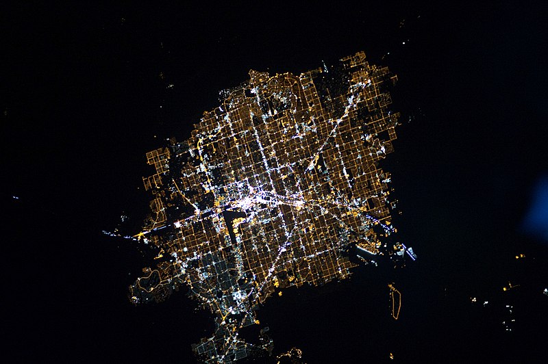
English: Las Vegas at night. (North is to the right of the picture.) The surrounding darkness of the desert presents a stark contrast to the brightly lit street grid of the developed area. The Vegas Strip is reputed to be the brightest spot on Earth due to the concentration of lights on its hotels and casinos. The tarmac of McCarran International Airport is dark by comparison, while the airstrips of Nellis Air Force Base on the north-eastern fringe are likewise dark. The dark mass of Frenchman Mountain borders the city to the east.
日期
来源 NASA Earth Observatory
作者 ISS Expedition 26 crew
相机位置36° 06′ 00″ 北, 115° 12′ 00″ 西 Kartographer map based on OpenStreetMap.在以下服务上查看本图像和附近其他图像: OpenStreetMapinfo
本图像或视频收录于美国国家航空航天局 (NASA)休斯顿太空中心(Johnson Space Center),其照片编号是: ISS026-E-6255

此标签不表示文件的著作权状态。任何文件在附有此标签的同時还需要一个有效的著作权标签请参阅许可协议说明页面以了解更多信息。
其他语言:

Image captured with a Nikon D3S digital camera using an 180 mm lens, and is provided by the ISS Crew Earth Observations experiment and Image Science & Analysis Laboratory, Johnson Space Center.

许可协议

Public domain 本文件完全由NASA创作,在美国属于公有领域。根据NASA的版权方针,NASA的材料除非另有声明否则不受版权保护。(参见Template:PD-USGov/zhNASA版权方针页面JPL图片使用方针。)
警告:
注解
InfoField
该图片含有注解:在维基媒体共享资源上查看注解

说明

添加一行文字以描述该文件所表现的内容

此文件中描述的项目

描绘内容

远征26 Chinese (China)(已转写)

36°6'0.000"N, 115°12'0.000"W

0.06666666666666666666

180 毫米

12,800

7,271,062 字节

2,832 像素

4,256 像素

image/jpeg

3a8bd3fd2809091adf6d179667bfd9b13cd600e7

文件历史

点击某个日期/时间查看对应时刻的文件。

日期/时间缩⁠略⁠图大小用户备注
当前2010年12月13日 (一) 10:362010年12月13日 (一) 10:36版本的缩略图4,256 × 2,832(6.93 MB)Originalwana{{Information |Description={{en|1=Las Vegas at night. The surrounding darkness of the desert presents a stark contrast to the brightly lit street grid of the developed area. The Vegas Strip is reputed to be the brightest spot on Earth due to the c

以下页面使用本文件:

全域文件用途

以下其他wiki使用此文件:

元数据