跳转到内容

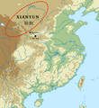
File:Xianyun area map.png

页面内容不支持其他语言。
這個文件來自維基共享資源
维基百科,自由的百科全书

原始文件 (1,652 × 1,808像素,文件大小:1.77 MB,MIME类型:image/png


摘要

描述
English: Xianyun area map
Reference: (23 November 2017) 《 Ancient China and its Eurasian Neighbors: Artifacts, Identity and Death in the Frontier, 3000–700 BCE》、​第186頁 DOI10.1017/9781108290555.005. "According to Li Feng’s study, based primarily on written sources, the “Xianyun”were a large-scale society with highly concentrated power that lived in an area that stretched from the Hetao (bend of the Yellow River) to the upper Yellow River Valley.The Xianyun were organized around coherent social units with a shared cultural tradition and background,laying the foundation for them to reconcile with each other to fight the Zhou together. “Xianyun” was probably a self-claimed title, and bronze inscriptions suggest that the Zhou called the Xianyun the “Rong,” indicating that it was a warlike group (Li Feng 2006:142–45)."
日期
来源
图片提取流程
本文件提取自另一个文件
:​Eastern China blank relief map.svg
原始文件
作者 Kanguole

许可协议

w:zh:知识共享
署名 相同方式共享
本文件采用知识共享署名-相同方式共享 4.0 国际许可协议授权。
您可以自由地:
  • 共享 – 复制、发行并传播本作品
  • 修改 – 改编作品
惟须遵守下列条件:
  • 署名 – 您必须对作品进行署名,提供授权条款的链接,并说明是否对原始内容进行了更改。您可以用任何合理的方式来署名,但不得以任何方式表明许可人认可您或您的使用。
  • 相同方式共享 – 如果您再混合、转换或者基于本作品进行创作,您必须以与原先许可协议相同或相兼容的许可协议分发您贡献的作品。

说明

添加一行文字以描述该文件所表现的内容
Xianyun area map

此文件中描述的项目

描繪內容

文件历史

点击某个日期/时间查看对应时刻的文件。

日期/时间缩⁠略⁠图大小用户备注
当前2023年11月10日 (五) 06:182023年11月10日 (五) 06:18版本的缩略图1,652 × 1,808(1.77 MB)पाटलिपुत्रBaicaopo
2023年11月7日 (二) 08:352023年11月7日 (二) 08:35版本的缩略图1,652 × 1,808(1.77 MB)पाटलिपुत्रformat
2023年11月7日 (二) 08:322023年11月7日 (二) 08:32版本的缩略图1,652 × 1,808(1.77 MB)पाटलिपुत्रUploaded a work by Kanguole from {{extracted from|File:Eastern China blank relief map.svg}} with UploadWizard

以下页面使用本文件:

全域文件用途

以下其他wiki使用此文件:

  • en.wikipedia.org上的用途

元数据