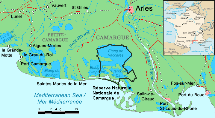
File:Camargue map.png
外观
Camargue_map.png (718 × 396像素,文件大小:42 KB,MIME类型:image/png)
文件历史
点击某个日期/时间查看对应时刻的文件。
| 日期/时间 | 缩略图 | 大小 | 用户 | 备注 | |
|---|---|---|---|---|---|
| 当前 | 2016年4月29日 (五) 21:34 |  | 718 × 396(42 KB) | Rsuessbr | Writing of Petite-Camargue corrected |
| 2015年8月10日 (一) 17:15 |  | 718 × 396(42 KB) | Rsuessrb | Added: limits of the natural park (according to a map published by snpn (Société Nationale de Protection de la Nature), 2015 | |
| 2012年3月20日 (二) 01:23 |  | 718 × 396(38 KB) | Ras67 | cropped | |
| 2006年8月16日 (三) 20:52 |  | 720 × 398(41 KB) | ChrisO | Map of the Camargue region, southern France By ~~~, derived from open source mapping | |
| 2006年8月16日 (三) 20:46 |  | 720 × 398(40 KB) | ChrisO | Map of the Camargue region, southern France By ~~~, derived from open source mapping |
文件用途
全域文件用途
以下其他wiki使用此文件:
- af.wikipedia.org上的用途
- ar.wikipedia.org上的用途
- az.wikipedia.org上的用途
- br.wikipedia.org上的用途
- co.wikipedia.org上的用途
- cs.wikipedia.org上的用途
- cy.wikipedia.org上的用途
- de.wikipedia.org上的用途
- en.wikipedia.org上的用途
- eo.wikipedia.org上的用途
- es.wikipedia.org上的用途
- fi.wikipedia.org上的用途
- fr.wikipedia.org上的用途
- gl.wikipedia.org上的用途
- hu.wikipedia.org上的用途
- id.wikipedia.org上的用途
- it.wikipedia.org上的用途
- ja.wikipedia.org上的用途
- ko.wikipedia.org上的用途
- lt.wikipedia.org上的用途
- nl.wikipedia.org上的用途
- nn.wikipedia.org上的用途
- no.wikipedia.org上的用途
- oc.wikipedia.org上的用途
查看此文件的更多全域用途。


